Anyway, the time arrived at last for the second recce weekend. This time we will have a third person joining me and Cathy. Jeff a friend and ex-colleague of both of us had rocked up after a work stint in the Philippines and was itching to get out in the hills. Promising not to go to hard on him we allowed him to "tag along".
Me and Jeff both live in the south, and Cathy up north, so me and Jeff drove up together from MK and met Cathy at the overnight camping place - Gargrave camp site (yes we had booked a campsite this time, with loos and a tap!) and then we drove back to the starting point for this weekend, near checkpoint 1 - Hebden Bridge. A special mention goes out to a sign-post we saw en route - "Slack Bottom". Much mirth was had by all :-)
 |
| Me, Jeff, and Cathy |
Off we went and immediately hit a steep uphill, which in the already hot morning soon got us all sweating. Me and Jeff were in shorts and Cathy chose to hide her legs, but even with the shorts it was hot going.
No dramas crossing Heptonstall Moor, but heading down towards a chain of lakes we did miss a hugely obvious right turn - complete with standing stone and a PW sign on the fence post, and ended up in a field with no way out except the way we entered, so we back-tracked and found the turn and off we went again (it seems all the chatting was contra-productive to navigating the paths).
We reached the lakes (Walshaw Dean Reservoirs), crossing over the middle dam (which was different from the map I had) and while on the dam we saw a pair or Ospreys, which was amazing.
 |
| The path alongside Walshaw Dean Reservoirs |
 |
| Giant caterpillar. FYI that is a tree in the foreground, not a twig as it looks like. |
Descending from Withins Height, we approached the ruins of a remote farm house, reported to be "Top Withens", the farmhouse featured in "Wuthering Heights". A brief food/water stop and we were off, nearly treading on a tiny vole which we saw on the path. Cathy prodded it to make sure it was alive, and it scurried off before she could stamp on it properly ;-)
We descended into the valley of Ponden Reservoir and climbed the steep side of the opposite valley. On the way up we were passed by a mountain biker obviously struggling in his slowest gear (did I mention it was very steep?) We said hello as he passed and I called out that he had better not stop and push as he would look very silly if he did, so of course as he was a man with pride, he was forced to carry on peddling and praying that he could continue doing so until out of sight.
As we climbed we reached Oakworth Moor and crossed The Sea. Yes we did really - look:
 |
| Clearly showing the Pennine Way crossing The Sea. |
Oakworth Moor turned into Ickornshaw Moor and we started our descent into the valley of Cowling.
At this point I aught to mention a goal we had, which was to get to the pub in Lothersdale (I forget its name) before it closed after the lunch time session. So we had been on a bit of a mission, watching the time and not stopping for very long, but by now it seemed we would miss the time by about half an hour, which was very disappointing as I was craving an ice cold pint of lemonade - my cold beverage of choice when in the hills.
Anyway, with this goal missed we stopped at a rather inviting spring. It had stone slabs around it and there was no signs of sheep standing in the fields above, so we risked it - and oh my that water was the best water I had drunk in ages. We filled up our bottles, had a bite to eat and much refreshed we set off again.
We were now in proper farmland, so crossing fields, chatting to farmers with amazing heavy Yorkshire accents - "ey up lad" and all that, it was so picturesque. Navigation was quite straight forward, but I am putting that down to being able to see for miles, it would be a very different story at night in January I am sure.
Reaching Lothersdale about an hour after the advertised closing time of the afore mentioned pub, we were astonished to find that the pub was open. It would be rude to ignore this omen, so drinks we had, sitting outside watching the world go by.
We set of refreshed (again) and started the long climb up to Elslack Moor (it seems this is a very "moory" area). Reaching the top, we also reached the only summit of the day so far, all other climbs had avoided the actual top, but this time we reached the actual summit of Pinhaw Beacon, took a photo and promptly headed off down towards Thornton-in-Craven.
 |
| Pinhaw Beacon summit cairn and Trig point. |
 |
| Double arched bridge. |
Arriving at out camp site we set up camp and relaxed, eating our dinners and were even given a chunk of fruit cake by our tent neighbour who was very impressed by the 26 miles we had covered that day.
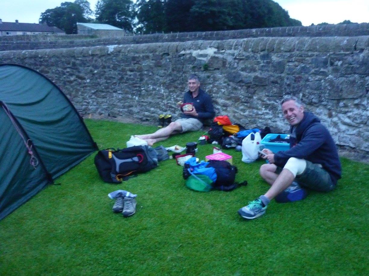 |
| Me and Jeff eating at the camp site, a chunk of fruit cake near my legs. |
Rising early as I do normally, Jeff had decided not to do the next day and so he stayed with Cathy. They would drive to the finish and then walk back towards me and meet me at or around the summit of Pen-y-Ghent, the final mountain before descending into Horton. So I set off on my lonesome. I had walked about 20 metres when I turned back - I had forgotten my walking poles which were in the van. So off I went again, take two.
Leaving Gargrave I missed the path as it left the road and headed out into the fields. I realised quite quickly and there was another path on the map which joined the Pennine Way about a mile further, so not to worry, just a small detour, but it was a point to mark on the map for next time.
The next large stretch was a lot of fields and farmland, so I had to pay close attention to field boundaries and stiles/gates etc. This bit was mentioned in the Spine pages of Facebook, stating that in the dark it was very tricky, so I kept my wits about me, making sure that I knew were I was exactly on the map all the time, even though I could easily see the way to go in daylight.
I arrived at Malham village with no dramas and headed up towards Malham cove. I have never been in this area before so it was amazing to see the huge cliffs of the cove as I ascended.
 |
| Malham Cove |
The path heads up to the left of the cove and then turns right at the top, going right over and above the cliffs. At the top it goes over a natural phenomenon (thanks spell-check) which is a Limestone Pavement. This is basically a limestone floor which has been shaped/sculpted by water and the weather to create huge gaps and cracks which in the dark could be interesting, but now, in daylight and sun it looked lovely.
 |
| Limestone Pavement above Malham Cove. |
Soon after leaving Malham Tarn the path starts to climb, and climb, and climb. This is the (very) long drag up Fountains Fell, Not really one of the most inspiring mountains I have ever seen, it is just a long boring slog, even worse than the Llanberis path up Snowdon, which in clear weather at least has some great views, this was just boring.
However, upon crossing the shoulder (yes the path even avoided the summit, arguably the most exciting part of any hill climb) the totally different view of Pen-y-Ghent came into view. This is a very picturesque mountain, with cliffs and everything.
 |
| Pen-y-Ghent |
Descending off Fountains Fell I passed a couple of people who were doing the whole Pennine Way. We exchanged small-talk and I think they were impressed when I told them we (I) had set off from Hebden Bridge the morning before (this was nearly 40 miles away by now). The descent is a bit of a pain as you go right down in the valley between Fountains Fell and Pen-y-Ghent, so you are made very aware that every step you go down, you will be going up again very soon.
Reaching the valley the rain was a bit heavier, so I paused to pop on my jacket. I still had my shorts on, but felt the need for the jacket just to keep the wetness in check.
Heading up the other side of the valley I was really looking forward to the climb. The two steep steps high up looked quite challenging (much more so then Fountains Fell) and i wondered what these would be like in a possibly icy January.
The area below these steps was heaving with people who were out walking for the day. It seemed a bit of a honey trap for families, some going up and some going down. I bypassed the crowds and headed up to the steep bit. It wasn't as bad as it looked and the steep bit was soon below me as i ran up the last section to the waiting Jeff and Cathy, who had been on the summit for over an hour waiting for me. I was baking hot after the climb (I had removed my waterproof to cool down) but they were wrapped up in all the layers they had.
We headed down quickly and it wasn't long before they started to warm up again.
 |
| Descending from Pen-y-Ghent |
And that is it. Recce trip number 2 sorted. Just one more to go in November and then its the real thing in January.
Anything taken from this weekend? No changes really, I just need to keep up the training. Kit wise i am all sorted, just a few key items to sort before the next recce, namely a decent sleeping bag, and then i am good to go.
So that's it - toodle pip.