It occurred to me earlier this year that I had no races booked at all for 2016. All my focus has been on "the main event" but that is in 2017 so it would have made my historical race calendar have an unsightly gap for this year...
So...
I booked a race. A marathon, for December.
This was in the spring of this year, so plenty of training time. Then training for January took over and because it is such a long race, all my training has been focused on long slow runs (or recce walks). That's not "most" but "ALL" my training.
For the uninitiated, marathon training usually varies between long slow runs (LSRs), speed work, tempo runs, and all sorts of other training sessions, designed to get you round in one piece and in a reasonable time.
Anyway... The day came, nice and dry and mild. Perfect racing weather. I had a plan of sorts. Based on my training of the year (all LSRs) I had ruled out sub 4 hours, and had pretty much decided that I would probably get somewhere around 4:30 but definitely sub 5 hours. So off i set.. (oh by the way, my race number was 49, the same as my age 😀 )
Running at a comfortable pace, and watching the racing snakes disappear into the distance, I was mildly surprised to see the first mile clock in at 9:07. Now considering all my training runs have been between 9:30 and 10:30 pace (that's minutes per mile in case you are wondering) I was somewhat worried that I had set out too fast (very common in races, especially for me).
I carried on at a comfortable pace, staying on the tail of various runners, just basically running and enjoying myself. Mile 2 clocked in at 8:38 - oops. And this continued mile after mile, in short, the first 15 miles were all under 9:00 pace. Now considering my training pace had all been way slower than this I can conclude that for distance races, running LSRs is the benchmark of training. Many beginners to the longer races cannot see how running long and slow can end up meaning a faster pace during the race. Well the above shows it does.
After 15 miles things did slow down somewhat, but only really to the slower end of my training pace, but to end up with a time of 4:15:34 after mentally setting a sub 5 to sub 4:30 finish, 15 minutes quicker that that was most welcome, especially considering I had done no speed work for well over a year.
So that's my only race of 2016, a "seasons best" but only because it was the only race this season.
5 weeks to go until "the main event".......
Gulp.....
Sunday, 11 December 2016
Monday, 28 November 2016
Spine Challenger training/recce weekend 3
Hello chaps
Well this is my last opportunity to race test everything in one go, while cementing the last bit of the route in my mind. I have made a few kit changes to avoid annoyances, and to iron out problems, the main ones some new front bottles, and a new waterproof jacket, thanks to The Climbers Shop for their continuing support.
So here was the plan. Me, Jeff, and Cathy to meet up in Gargrave and cover the last 35 miles of the route to the finish, setting off at 7pm to cover a large chunk in darkness to also fine tune the navigation, as the first half of this bit is notoriously difficult.
As the weekend approached Jeff (who has never covered anything like this distance in one go) mysteriously got sent to Manilla for 7 days - which conveniently included "our" weekend. So one down, just Me and Cathy left. Then 10 days before "our" weekend, Cathy announced "I fell & busted my shoulder" half way into her last 20 mile training run. As you can imagine we were most displeased with the situation. Cathy spent some quality time with her husband Paul in A&E to get things checked out, luckily her shoulder was not broken or dislocated, just bruised (her shoulder and her ego).
Anyway, 10 days later with her taking things easy/gradually building it back up, and me sending telepathic healing thoughts her way, her shoulder had recovered enough for her to take the plunge and tackle the full 35 miles (rather than only covering part of it which was our back-up plan).
So on a cold crisp November evening I was stood at Gargrave railway station waiting for Cathy's train to arrive. In true Chris fashion of not wanting to be late, I had been at Gargrave for 2 hours already, having sorted out a place to park for the night, found where the path left the village, and where it entered the village, and the chip shop, and the public toilet, so all was ready.
Cathy's train arrived and I drove her to the car park. It was free parking for 23 hours, so unless anything went drastically wrong on our trip we should have plenty of time parked here.
We fuelled up at the chippy, geared up, and set off from the car at 7:10pm ready for our night assault.
Setting off from Gargrave, (and avid followers of my blog will have read this), I was acutely aware that I had missed the path not long after leaving the village on my last recce. Chatting away as we walked up the road, we nearly missed it again, only spotting the faded sign hidden in the shrubbery at the last minute, so off we set across the soggy fields.
This first bit was navigationally challenging, crossing fields, hitting the field boundaries at the correct places to find the gate or stile, but all went swimmingly. It was soon evident that this area had had plenty of rain over the last few days because any small hollow was extra soggy, and the ground under foot was constantly wet and squelchy, but our footwear coped admirably, shedding the water and mud with ease.
After crossing a few miles of fields we hit the river Aire. This was to be our handrail until we arrived at the village of Malham. Checking the map frequently to check our route and our progress as this section was supposed to be challenging, I ended up each time putting the map back and saying to myself "keep the river to the left". That was it, it seemed fairly straight forward. "Navigationally challenging"? Pah! it was simple...
Following the river for a few miles it was again evident that a lot of water had been here before us, with obvious flood tidemarks. If the water was this high during the event it could make for some interesting wading sections...
Apart from the missing 'horse-in-this-field' (that I had mentally marked on my map from my last visit), nothing else of significance happened in this section, and we arrived at Malham village at about 9:50pm.
Walking through Malham in full kit, with mud plastered on our lower legs, while "normal" people were milling around the pubs, was a little weird, (these would turn out to be the last people we saw for the next 12 hours) but we soon left civilisation and headed upwards towards the splendour of Malham Cove.
Walking up the steps beside the cove it was soon apparent how slippery the limestone was underfoot in this damp night. And once we reached the top it was positively treacherous walking across the limestone pavement at the top. The rock was very greasy and the huge gaping ankle breaking gaps in between meant for very slow progress.
We negotiated our way to more grippy ground and then set off at a fair old pace up the hanging valley. Cows! Not the usual place to meet cows I know, but there they were in the gloom (or their eyes anyway) and we heard them scrambling up the scree slopes to get out of our way.
Looking back from whence we came, the lights of the valleys glittered in the dark, and the stars and full moon were out in their splendour. I pointed out a few constellations to Cathy and we marvelled at the brightness of the moon (this was the night before the November "super moon" so it was rather bright). At one point we carried on walking without our head torches on and we could see clearly enough without.
Carrying on, we skirted the shore of Malham Tarn, heading to the activity centre which would be the second checkpoint of the race. It is a National Trust place and as luck would have it they had left one of their discovery rooms open, so it would have been rude not to take advantage and grab a bite to eat in the relative warmth and dryness of it.

Setting off again, we headed out and upwards to the two high points of the weekend. Fountains fell followed by Pen-Y-Ghent (PYG). As stated in my last blog, the ascent up Fountains Fell was a long boring slog, but fortunately it was shortened somewhat by the darkness and not being able to see the path disappearing over the horizon. We descended off Fountains fell and started the climb up PYG, eventually summiting at 3.30am after an uneventful climb.
The decent was another long and boring slog, not helped by the fact that it was gone 4am and we hadn't slept for ages. I was nodding as I walked, not good.
We arrived at Horton in Ribblesdale at about 5:30am and promptly found the public loos. We topped up our water and then I was invited into the ladies loo by Cathy. Having never ventured into a ladies loo before, I entered with some trepidation. Actually it was quite nice, it certainly smelt better than the men's loo, so we plonked ourselves down and lit our stoves for a hot breakfast. Cathy obviously wasn't too happy with her first pot of water, so she threw it across the floor in disgust (she said it was an accident but I don't believe her) and promptly started heating another pot.
Suitably refreshed we set off on the last leg. About 12 miles to go, mostly uphill apart from the final descent. The path steadily climbed, heading up to an old packhorse road. Cathy got a bit worried at one point in the dark, wondering if we had taken a wrong turning, but I checked the map and pointed to where we were on the map to reassure her. To be 100% safe I dug out my GPS and fired it up - it confirmed I was spot on so she was happy with this and off we set.
As morning approached the temperature plummeted and we slipped a layer on, and I covered up terrorist style with my black hat and buff.:

Not long afterwards the sun started to light up the sky as morning began to break. We were treated with a fantastic sunrise over PYG:
The path kept rising, but now we were able to see where we had to go, it looked ages, and it was. We were back up in the hills again, completely alone, gorgeous scenery, weather, and it just made the morning so lovely despite the long slog up the cam road.
Before too long we started the final descent into Hawes, what would be the finish of January's race. The final bit twiddling about on fields and things, could make the last bit of navigation interesting.
We finally arrived at Cathy's car at mid day, and promptly drove to the train station to drop me off so I could get the train back to Gargrave - a whole new adventure for me as I am not the most seasoned train traveller in the world, but even I know that looking out of the window while travelling on a train as it goes over the Ribble head viaduct was something special, so I sat there, all muddy and sweaty with a lovely glow of satisfaction. 35 miles of walking in lovely weather (cold and dry) with a great companion.
The next time I will see this scenery I would be racing. Even if the weather is half as nice as this weekend, it will be awesome. Roll on January 14th... 😊
Well this is my last opportunity to race test everything in one go, while cementing the last bit of the route in my mind. I have made a few kit changes to avoid annoyances, and to iron out problems, the main ones some new front bottles, and a new waterproof jacket, thanks to The Climbers Shop for their continuing support.
So here was the plan. Me, Jeff, and Cathy to meet up in Gargrave and cover the last 35 miles of the route to the finish, setting off at 7pm to cover a large chunk in darkness to also fine tune the navigation, as the first half of this bit is notoriously difficult.
As the weekend approached Jeff (who has never covered anything like this distance in one go) mysteriously got sent to Manilla for 7 days - which conveniently included "our" weekend. So one down, just Me and Cathy left. Then 10 days before "our" weekend, Cathy announced "I fell & busted my shoulder" half way into her last 20 mile training run. As you can imagine we were most displeased with the situation. Cathy spent some quality time with her husband Paul in A&E to get things checked out, luckily her shoulder was not broken or dislocated, just bruised (her shoulder and her ego).
Anyway, 10 days later with her taking things easy/gradually building it back up, and me sending telepathic healing thoughts her way, her shoulder had recovered enough for her to take the plunge and tackle the full 35 miles (rather than only covering part of it which was our back-up plan).
So on a cold crisp November evening I was stood at Gargrave railway station waiting for Cathy's train to arrive. In true Chris fashion of not wanting to be late, I had been at Gargrave for 2 hours already, having sorted out a place to park for the night, found where the path left the village, and where it entered the village, and the chip shop, and the public toilet, so all was ready.
Cathy's train arrived and I drove her to the car park. It was free parking for 23 hours, so unless anything went drastically wrong on our trip we should have plenty of time parked here.
We fuelled up at the chippy, geared up, and set off from the car at 7:10pm ready for our night assault.
 |
| Me and Cathy at the start in Gargrave. |
 |
| The path crossing soggy fields. |
After crossing a few miles of fields we hit the river Aire. This was to be our handrail until we arrived at the village of Malham. Checking the map frequently to check our route and our progress as this section was supposed to be challenging, I ended up each time putting the map back and saying to myself "keep the river to the left". That was it, it seemed fairly straight forward. "Navigationally challenging"? Pah! it was simple...
Following the river for a few miles it was again evident that a lot of water had been here before us, with obvious flood tidemarks. If the water was this high during the event it could make for some interesting wading sections...
Apart from the missing 'horse-in-this-field' (that I had mentally marked on my map from my last visit), nothing else of significance happened in this section, and we arrived at Malham village at about 9:50pm.
Walking through Malham in full kit, with mud plastered on our lower legs, while "normal" people were milling around the pubs, was a little weird, (these would turn out to be the last people we saw for the next 12 hours) but we soon left civilisation and headed upwards towards the splendour of Malham Cove.
 |
Malham cove in the daylight. |
 |
| Above Malham cove on the (slippery) limestone pavement. |
Looking back from whence we came, the lights of the valleys glittered in the dark, and the stars and full moon were out in their splendour. I pointed out a few constellations to Cathy and we marvelled at the brightness of the moon (this was the night before the November "super moon" so it was rather bright). At one point we carried on walking without our head torches on and we could see clearly enough without.
Carrying on, we skirted the shore of Malham Tarn, heading to the activity centre which would be the second checkpoint of the race. It is a National Trust place and as luck would have it they had left one of their discovery rooms open, so it would have been rude not to take advantage and grab a bite to eat in the relative warmth and dryness of it.

Setting off again, we headed out and upwards to the two high points of the weekend. Fountains fell followed by Pen-Y-Ghent (PYG). As stated in my last blog, the ascent up Fountains Fell was a long boring slog, but fortunately it was shortened somewhat by the darkness and not being able to see the path disappearing over the horizon. We descended off Fountains fell and started the climb up PYG, eventually summiting at 3.30am after an uneventful climb.
 |
| Selfie at the summit of PYG |
We arrived at Horton in Ribblesdale at about 5:30am and promptly found the public loos. We topped up our water and then I was invited into the ladies loo by Cathy. Having never ventured into a ladies loo before, I entered with some trepidation. Actually it was quite nice, it certainly smelt better than the men's loo, so we plonked ourselves down and lit our stoves for a hot breakfast. Cathy obviously wasn't too happy with her first pot of water, so she threw it across the floor in disgust (she said it was an accident but I don't believe her) and promptly started heating another pot.
 |
| In the ladies loo. |
As morning approached the temperature plummeted and we slipped a layer on, and I covered up terrorist style with my black hat and buff.:

Not long afterwards the sun started to light up the sky as morning began to break. We were treated with a fantastic sunrise over PYG:
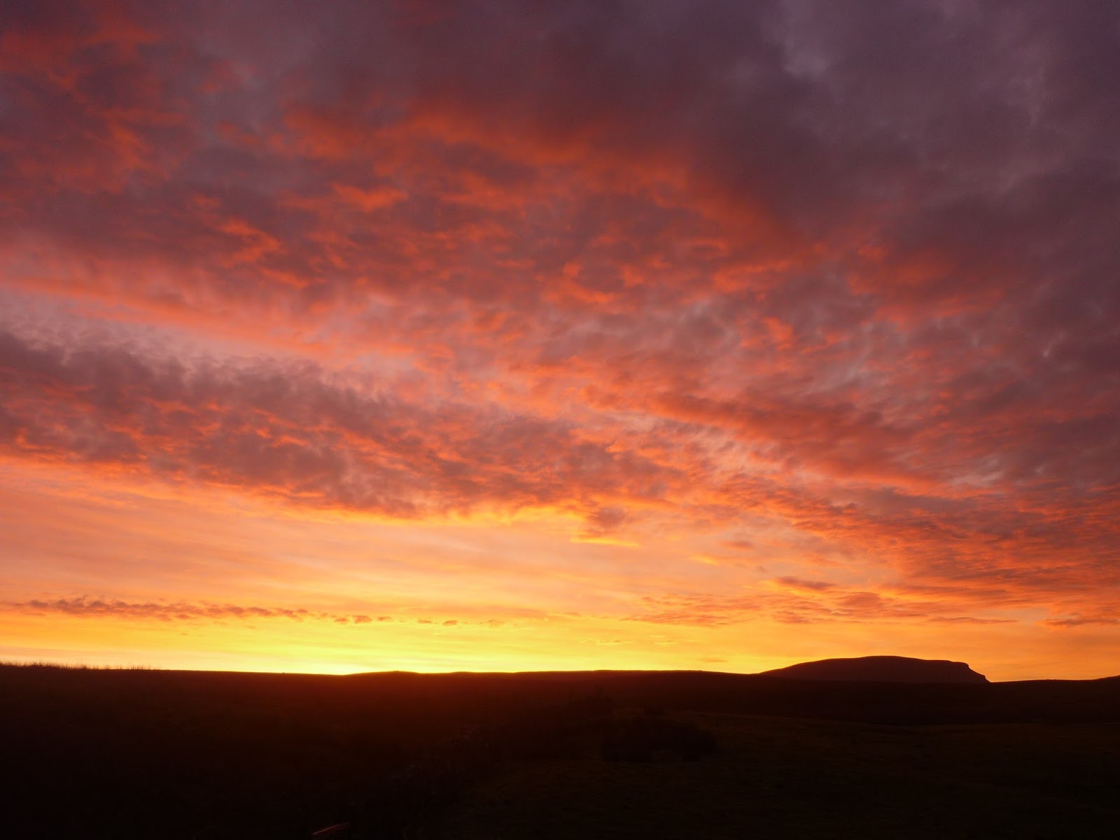 |
| Sunrise over Pen-Y-Ghent |
Before too long we started the final descent into Hawes, what would be the finish of January's race. The final bit twiddling about on fields and things, could make the last bit of navigation interesting.
We finally arrived at Cathy's car at mid day, and promptly drove to the train station to drop me off so I could get the train back to Gargrave - a whole new adventure for me as I am not the most seasoned train traveller in the world, but even I know that looking out of the window while travelling on a train as it goes over the Ribble head viaduct was something special, so I sat there, all muddy and sweaty with a lovely glow of satisfaction. 35 miles of walking in lovely weather (cold and dry) with a great companion.
The next time I will see this scenery I would be racing. Even if the weather is half as nice as this weekend, it will be awesome. Roll on January 14th... 😊
Thursday, 27 October 2016
Under the cover of darkness
So the evenings are drawing in and the mornings are proper dark for the duration of my training runs... which means... no more embarrassing runs around the villages in full kit while getting strange looks from normal people.
Yes, as the event draws closer, my attention has swayed to specific training runs with full kit. That's boots, full trousers, layered top, full pack (about 6kg) and my poles (walking sticks, not eastern Europeans).
I have found a few mostly off road circular routes around the villages, crossing fields and traversing woodland, all on public footpaths I add. Some of them have been challenging in the dark, finding my way across a field with not much of a path - but then that's exactly the sort of training i need.
Anyway - these runs are now incorporated into my running, at least one per week. It makes a huge difference running in this stuff, the pace is slower and the posture is completely different, so new muscles come into play.
But the good thing is it is all dark, so not many people are about to see my antics - only the odd runner as i get back into civilisation, and they must think "coo he must be training for something extreme carrying all that kit" and i think to myself, with a small but excitable grin - yep.
Friday, 26 August 2016
Spine Challenger training/recce weekend 2.
Pull up a chair and make yourself a hot beverage - this is going to be a long one.....
Anyway, the time arrived at last for the second recce weekend. This time we will have a third person joining me and Cathy. Jeff a friend and ex-colleague of both of us had rocked up after a work stint in the Philippines and was itching to get out in the hills. Promising not to go to hard on him we allowed him to "tag along".
Me and Jeff both live in the south, and Cathy up north, so me and Jeff drove up together from MK and met Cathy at the overnight camping place - Gargrave camp site (yes we had booked a campsite this time, with loos and a tap!) and then we drove back to the starting point for this weekend, near checkpoint 1 - Hebden Bridge. A special mention goes out to a sign-post we saw en route - "Slack Bottom". Much mirth was had by all :-)
So we parked up at the side of the road, after driving past the footpath down to Checkpoint 1, so I could see where it disappeared between the houses. Then I geared up. I had done a few tweaks to my gear, the main two were lowering the front pouch from the chest to the waist, and adding 2 front loading water bottles rather than an internal water bladder. For this trip only I also carried some extra soft water bottles in my bag as the weather forecast was hot and sunny for the whole weekend and I wasn't sure of the available water en-route.
Off we went and immediately hit a steep uphill, which in the already hot morning soon got us all sweating. Me and Jeff were in shorts and Cathy chose to hide her legs, but even with the shorts it was hot going.
No dramas crossing Heptonstall Moor, but heading down towards a chain of lakes we did miss a hugely obvious right turn - complete with standing stone and a PW sign on the fence post, and ended up in a field with no way out except the way we entered, so we back-tracked and found the turn and off we went again (it seems all the chatting was contra-productive to navigating the paths).
We reached the lakes (Walshaw Dean Reservoirs), crossing over the middle dam (which was different from the map I had) and while on the dam we saw a pair or Ospreys, which was amazing.
Leaving the reservoirs we headed back up into the moors, crossing Withins Height, which seemed to be the home of many HUGE caterpillars, which strangely were very widely spaced and we never saw two or more together, leading to various hypotheses of why this was. My idea was they were a species of killer caterpillars, and had eaten all the other caterpillars around them in a half mile radius. Cathy suggested there were hundreds of them hidden in the heather and the ones we saw were the outcasts, forced to roam the path, away from the safety of the heather. Jeff just stood by smiling and nodding, not wanting to get involved.
Descending from Withins Height, we approached the ruins of a remote farm house, reported to be "Top Withens", the farmhouse featured in "Wuthering Heights". A brief food/water stop and we were off, nearly treading on a tiny vole which we saw on the path. Cathy prodded it to make sure it was alive, and it scurried off before she could stamp on it properly ;-)
We descended into the valley of Ponden Reservoir and climbed the steep side of the opposite valley. On the way up we were passed by a mountain biker obviously struggling in his slowest gear (did I mention it was very steep?) We said hello as he passed and I called out that he had better not stop and push as he would look very silly if he did, so of course as he was a man with pride, he was forced to carry on peddling and praying that he could continue doing so until out of sight.
As we climbed we reached Oakworth Moor and crossed The Sea. Yes we did really - look:
Oakworth Moor turned into Ickornshaw Moor and we started our descent into the valley of Cowling.
At this point I aught to mention a goal we had, which was to get to the pub in Lothersdale (I forget its name) before it closed after the lunch time session. So we had been on a bit of a mission, watching the time and not stopping for very long, but by now it seemed we would miss the time by about half an hour, which was very disappointing as I was craving an ice cold pint of lemonade - my cold beverage of choice when in the hills.
Anyway, with this goal missed we stopped at a rather inviting spring. It had stone slabs around it and there was no signs of sheep standing in the fields above, so we risked it - and oh my that water was the best water I had drunk in ages. We filled up our bottles, had a bite to eat and much refreshed we set off again.
We were now in proper farmland, so crossing fields, chatting to farmers with amazing heavy Yorkshire accents - "ey up lad" and all that, it was so picturesque. Navigation was quite straight forward, but I am putting that down to being able to see for miles, it would be a very different story at night in January I am sure.
Reaching Lothersdale about an hour after the advertised closing time of the afore mentioned pub, we were astonished to find that the pub was open. It would be rude to ignore this omen, so drinks we had, sitting outside watching the world go by.
We set of refreshed (again) and started the long climb up to Elslack Moor (it seems this is a very "moory" area). Reaching the top, we also reached the only summit of the day so far, all other climbs had avoided the actual top, but this time we reached the actual summit of Pinhaw Beacon, took a photo and promptly headed off down towards Thornton-in-Craven.
Crossing the valley of Thornton we crossed some more farmland and hit the Leeds and Liverpool Canal. The Pennine Way dips under an amazing double arched bridge - I have never seen one before - so I took a photo:
We knew we were on the final stretch now as this same canal was next to our camp site, so we headed off in much merriment, even chuckling as we crossed a really smelly field that had obviously just been "slurried".
Arriving at out camp site we set up camp and relaxed, eating our dinners and were even given a chunk of fruit cake by our tent neighbour who was very impressed by the 26 miles we had covered that day.
We slept very well (or at least I did).
Rising early as I do normally, Jeff had decided not to do the next day and so he stayed with Cathy. They would drive to the finish and then walk back towards me and meet me at or around the summit of Pen-y-Ghent, the final mountain before descending into Horton. So I set off on my lonesome. I had walked about 20 metres when I turned back - I had forgotten my walking poles which were in the van. So off I went again, take two.
Leaving Gargrave I missed the path as it left the road and headed out into the fields. I realised quite quickly and there was another path on the map which joined the Pennine Way about a mile further, so not to worry, just a small detour, but it was a point to mark on the map for next time.
The next large stretch was a lot of fields and farmland, so I had to pay close attention to field boundaries and stiles/gates etc. This bit was mentioned in the Spine pages of Facebook, stating that in the dark it was very tricky, so I kept my wits about me, making sure that I knew were I was exactly on the map all the time, even though I could easily see the way to go in daylight.
I arrived at Malham village with no dramas and headed up towards Malham cove. I have never been in this area before so it was amazing to see the huge cliffs of the cove as I ascended.
The path heads up to the left of the cove and then turns right at the top, going right over and above the cliffs. At the top it goes over a natural phenomenon (thanks spell-check) which is a Limestone Pavement. This is basically a limestone floor which has been shaped/sculpted by water and the weather to create huge gaps and cracks which in the dark could be interesting, but now, in daylight and sun it looked lovely.
The path turns away from the cove and up a dry valley, which ages ago held the river which went over Malham Cove, but now is deep underground. The path passes below Malham Tarn and skirts it to the other side where the next checkpoint is (and for me the last one until the finish).
Soon after leaving Malham Tarn the path starts to climb, and climb, and climb. This is the (very) long drag up Fountains Fell, Not really one of the most inspiring mountains I have ever seen, it is just a long boring slog, even worse than the Llanberis path up Snowdon, which in clear weather at least has some great views, this was just boring.
However, upon crossing the shoulder (yes the path even avoided the summit, arguably the most exciting part of any hill climb) the totally different view of Pen-y-Ghent came into view. This is a very picturesque mountain, with cliffs and everything.
Pen-y-Ghent looked miles away when I first saw it, and the finish was on the other side, so I still had a fair way to go. It had started to lightly rain by now, although my waterproof was not necessary just yet. I was storming along so any wetness soon boiled away.
Descending off Fountains Fell I passed a couple of people who were doing the whole Pennine Way. We exchanged small-talk and I think they were impressed when I told them we (I) had set off from Hebden Bridge the morning before (this was nearly 40 miles away by now). The descent is a bit of a pain as you go right down in the valley between Fountains Fell and Pen-y-Ghent, so you are made very aware that every step you go down, you will be going up again very soon.
Reaching the valley the rain was a bit heavier, so I paused to pop on my jacket. I still had my shorts on, but felt the need for the jacket just to keep the wetness in check.
Heading up the other side of the valley I was really looking forward to the climb. The two steep steps high up looked quite challenging (much more so then Fountains Fell) and i wondered what these would be like in a possibly icy January.
The area below these steps was heaving with people who were out walking for the day. It seemed a bit of a honey trap for families, some going up and some going down. I bypassed the crowds and headed up to the steep bit. It wasn't as bad as it looked and the steep bit was soon below me as i ran up the last section to the waiting Jeff and Cathy, who had been on the summit for over an hour waiting for me. I was baking hot after the climb (I had removed my waterproof to cool down) but they were wrapped up in all the layers they had.
We headed down quickly and it wasn't long before they started to warm up again.
The last bit into Horton was uneventful, just another rather long path, which seemed longer due to the miles already covered. We stopped at the cafe at the bottom, I had another lemonade, and then we plodded off to the van (which i noted was parked in the farthest possible corner of the car park - not great when you had covered 50 odd miles that weekend).
And that is it. Recce trip number 2 sorted. Just one more to go in November and then its the real thing in January.
Anything taken from this weekend? No changes really, I just need to keep up the training. Kit wise i am all sorted, just a few key items to sort before the next recce, namely a decent sleeping bag, and then i am good to go.
So that's it - toodle pip.
Anyway, the time arrived at last for the second recce weekend. This time we will have a third person joining me and Cathy. Jeff a friend and ex-colleague of both of us had rocked up after a work stint in the Philippines and was itching to get out in the hills. Promising not to go to hard on him we allowed him to "tag along".
Me and Jeff both live in the south, and Cathy up north, so me and Jeff drove up together from MK and met Cathy at the overnight camping place - Gargrave camp site (yes we had booked a campsite this time, with loos and a tap!) and then we drove back to the starting point for this weekend, near checkpoint 1 - Hebden Bridge. A special mention goes out to a sign-post we saw en route - "Slack Bottom". Much mirth was had by all :-)
 |
| Me, Jeff, and Cathy |
Off we went and immediately hit a steep uphill, which in the already hot morning soon got us all sweating. Me and Jeff were in shorts and Cathy chose to hide her legs, but even with the shorts it was hot going.
No dramas crossing Heptonstall Moor, but heading down towards a chain of lakes we did miss a hugely obvious right turn - complete with standing stone and a PW sign on the fence post, and ended up in a field with no way out except the way we entered, so we back-tracked and found the turn and off we went again (it seems all the chatting was contra-productive to navigating the paths).
We reached the lakes (Walshaw Dean Reservoirs), crossing over the middle dam (which was different from the map I had) and while on the dam we saw a pair or Ospreys, which was amazing.
 |
| The path alongside Walshaw Dean Reservoirs |
 |
| Giant caterpillar. FYI that is a tree in the foreground, not a twig as it looks like. |
Descending from Withins Height, we approached the ruins of a remote farm house, reported to be "Top Withens", the farmhouse featured in "Wuthering Heights". A brief food/water stop and we were off, nearly treading on a tiny vole which we saw on the path. Cathy prodded it to make sure it was alive, and it scurried off before she could stamp on it properly ;-)
We descended into the valley of Ponden Reservoir and climbed the steep side of the opposite valley. On the way up we were passed by a mountain biker obviously struggling in his slowest gear (did I mention it was very steep?) We said hello as he passed and I called out that he had better not stop and push as he would look very silly if he did, so of course as he was a man with pride, he was forced to carry on peddling and praying that he could continue doing so until out of sight.
As we climbed we reached Oakworth Moor and crossed The Sea. Yes we did really - look:
 |
| Clearly showing the Pennine Way crossing The Sea. |
Oakworth Moor turned into Ickornshaw Moor and we started our descent into the valley of Cowling.
At this point I aught to mention a goal we had, which was to get to the pub in Lothersdale (I forget its name) before it closed after the lunch time session. So we had been on a bit of a mission, watching the time and not stopping for very long, but by now it seemed we would miss the time by about half an hour, which was very disappointing as I was craving an ice cold pint of lemonade - my cold beverage of choice when in the hills.
Anyway, with this goal missed we stopped at a rather inviting spring. It had stone slabs around it and there was no signs of sheep standing in the fields above, so we risked it - and oh my that water was the best water I had drunk in ages. We filled up our bottles, had a bite to eat and much refreshed we set off again.
We were now in proper farmland, so crossing fields, chatting to farmers with amazing heavy Yorkshire accents - "ey up lad" and all that, it was so picturesque. Navigation was quite straight forward, but I am putting that down to being able to see for miles, it would be a very different story at night in January I am sure.
Reaching Lothersdale about an hour after the advertised closing time of the afore mentioned pub, we were astonished to find that the pub was open. It would be rude to ignore this omen, so drinks we had, sitting outside watching the world go by.
We set of refreshed (again) and started the long climb up to Elslack Moor (it seems this is a very "moory" area). Reaching the top, we also reached the only summit of the day so far, all other climbs had avoided the actual top, but this time we reached the actual summit of Pinhaw Beacon, took a photo and promptly headed off down towards Thornton-in-Craven.
 |
| Pinhaw Beacon summit cairn and Trig point. |
 |
| Double arched bridge. |
Arriving at out camp site we set up camp and relaxed, eating our dinners and were even given a chunk of fruit cake by our tent neighbour who was very impressed by the 26 miles we had covered that day.
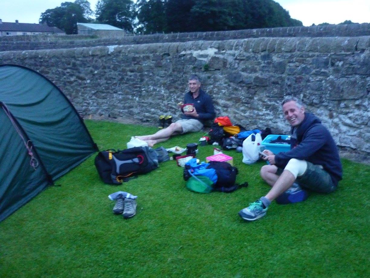 |
| Me and Jeff eating at the camp site, a chunk of fruit cake near my legs. |
Rising early as I do normally, Jeff had decided not to do the next day and so he stayed with Cathy. They would drive to the finish and then walk back towards me and meet me at or around the summit of Pen-y-Ghent, the final mountain before descending into Horton. So I set off on my lonesome. I had walked about 20 metres when I turned back - I had forgotten my walking poles which were in the van. So off I went again, take two.
Leaving Gargrave I missed the path as it left the road and headed out into the fields. I realised quite quickly and there was another path on the map which joined the Pennine Way about a mile further, so not to worry, just a small detour, but it was a point to mark on the map for next time.
The next large stretch was a lot of fields and farmland, so I had to pay close attention to field boundaries and stiles/gates etc. This bit was mentioned in the Spine pages of Facebook, stating that in the dark it was very tricky, so I kept my wits about me, making sure that I knew were I was exactly on the map all the time, even though I could easily see the way to go in daylight.
I arrived at Malham village with no dramas and headed up towards Malham cove. I have never been in this area before so it was amazing to see the huge cliffs of the cove as I ascended.
 |
| Malham Cove |
The path heads up to the left of the cove and then turns right at the top, going right over and above the cliffs. At the top it goes over a natural phenomenon (thanks spell-check) which is a Limestone Pavement. This is basically a limestone floor which has been shaped/sculpted by water and the weather to create huge gaps and cracks which in the dark could be interesting, but now, in daylight and sun it looked lovely.
 |
| Limestone Pavement above Malham Cove. |
Soon after leaving Malham Tarn the path starts to climb, and climb, and climb. This is the (very) long drag up Fountains Fell, Not really one of the most inspiring mountains I have ever seen, it is just a long boring slog, even worse than the Llanberis path up Snowdon, which in clear weather at least has some great views, this was just boring.
However, upon crossing the shoulder (yes the path even avoided the summit, arguably the most exciting part of any hill climb) the totally different view of Pen-y-Ghent came into view. This is a very picturesque mountain, with cliffs and everything.
 |
| Pen-y-Ghent |
Descending off Fountains Fell I passed a couple of people who were doing the whole Pennine Way. We exchanged small-talk and I think they were impressed when I told them we (I) had set off from Hebden Bridge the morning before (this was nearly 40 miles away by now). The descent is a bit of a pain as you go right down in the valley between Fountains Fell and Pen-y-Ghent, so you are made very aware that every step you go down, you will be going up again very soon.
Reaching the valley the rain was a bit heavier, so I paused to pop on my jacket. I still had my shorts on, but felt the need for the jacket just to keep the wetness in check.
Heading up the other side of the valley I was really looking forward to the climb. The two steep steps high up looked quite challenging (much more so then Fountains Fell) and i wondered what these would be like in a possibly icy January.
The area below these steps was heaving with people who were out walking for the day. It seemed a bit of a honey trap for families, some going up and some going down. I bypassed the crowds and headed up to the steep bit. It wasn't as bad as it looked and the steep bit was soon below me as i ran up the last section to the waiting Jeff and Cathy, who had been on the summit for over an hour waiting for me. I was baking hot after the climb (I had removed my waterproof to cool down) but they were wrapped up in all the layers they had.
We headed down quickly and it wasn't long before they started to warm up again.
 |
| Descending from Pen-y-Ghent |
And that is it. Recce trip number 2 sorted. Just one more to go in November and then its the real thing in January.
Anything taken from this weekend? No changes really, I just need to keep up the training. Kit wise i am all sorted, just a few key items to sort before the next recce, namely a decent sleeping bag, and then i am good to go.
So that's it - toodle pip.
Friday, 29 July 2016
The killing fields
I had a lovely run this morning. I went out on a variation of my easy five miler, along the country roads around our village. About a mile in I saw a lovely red kite flying over a field next to the road, it was quite low, lower than the tree tops so you could clearly see its rusty coloured plumage rather than the usual forked tail silhouette.
Carrying on through the lanes and round the corner a bit, a pair of red kites flew out of a tree I was running under, one swooping across the top of the roadside hedge, they really are huge birds. Looking up I saw them, one, two, three, four... they kept coming, and culminating in a flock of eight fully grown red kites, all in the same area, presumably a good food source was nearby to support so many hunters,
To top the run off, a minute or so later a buzzard and a kestrel also made an appearance.
Clearly not a good day for mice.
Thursday, 7 July 2016
I just made a training plan
So after a few months of bumbling about, running on and off, and varying the distance and the terrain, I thought it would be best to actually put something down more formal so I could structure my training better than I had been doing.
I sat down and had a chat with myself. What sort of training do I need to cover for this event? (I said to myself). 'Well Chris' I replied, You need to practice carrying your pack, you need to practice running in boots, you need to practice navigation, and night navigation, and you need to put in some long runs - and finally combine everything.
Hmm interesting. Well its the middle of summer at the moment so to do anything in the dark would mean staying up until 11pm, or getting up before 4am, which is just daft, so I will wait until the nights draw in to do the dark stuff.
Navigation would also be a bit of a challenge as I pretty much know the general area around me, so that will need to wait until I travel a bit further away from home.
Which leaves me with the running with/without various bits of kit. So my plan (for the time being) ends up like this:
Mon: Rest day.
Tue: Normal run.
Wed: Walk/run in boots.
Thurs: Run with pack (in running kit).
Fri: Normal run
Sat: Normal run
Sun: Walk/run in boots and with pack.
The more observant will see I have not included distances in this plan. They will vary depending on time available and will (generally) increase (especially the weekend ones) as the months progress. The mid week runs are really limited to length as I run in the morning before work, and getting up before 5am is difficult enough, so bringing it even earlier would just be silly
So that's it, I did a nice 10m run around the country lanes on Tue, a simple 3m walk around the village on Wed (in my boots), a 5m run with my pack (loaded with about 7kg of kit) this morning. All good, although the front loading bottles may need adjusting a bit higher to avoid bruised ribs.
******
On a closing note; due to the overwhelming amount of comments I have received from one of my previous posts, I need to point out that Cathy is a very dear friend (not in that way) that I have known for ages, so to call her a "lazy bint" was perfectly acceptable, and in no way was this comment intended to cause upset or anguish, no matter how true it might (or might not) have been. :-)Friday, 10 June 2016
I seemed to have acquired a dog
Not for life or anything, Lee our son (and his son (our grandson)) is staying while he looks for a new place to live, and he occasionally looks after Millie, his springer spaniel. She doesn't get as much exercise as a springer should get, so she is loving all these early morning runs through the woods and fields surrounding Deanshanger.
She broke her collar this morning, oops.
She broke her collar this morning, oops.
Thursday, 9 June 2016
Spine Challenger training/recce weekend 1.
So, here we are in mid may and I am off to Derbyshire for the first of 3 training/recce weekends in preparation for my January race - The Spine Challenger.
In case you don't know what this is about, here is the blurb from their website:
The MONTANE® Spine® Challenger is a non-stop, 108 mile race between Edale and Hawes with a time limit of 60hrs. This challenging and extremely technical section of the Pennine Way is a physically and psychologically demanding route that demands concentration, good physical fitness, resolve and respect. The MONTANE® Spine® Challenger is a notoriously difficult event in its own right and should be considered as having a similar degree of difficulty as the longer MONTANE® Spine® Race.
From appearances alone 60 hours looks like ample time to complete this course. However, appearances can be deceptive. The rugged and very technical nature of this race is mentally taxing, as you have to constantly be aware of foot placement in icy conditions, weather systems, navigation, available daylight and self-management.
In the 5 previous editions of the race competitors have faced storm force winds, snow, extreme ice, bogs, fog, hail, mud and almost anything else you can think of!
Sounds fun doesn't it?
Anyway, I met my friend Cathy at the half way point. She was going to do day one with me and then drive to the finish and walk back to meet me, turn round and walk back with me to the finish so we could then drive back to the start where I had left my car.
Cathy has the very good fortune of co-owning a small chain of specialist outdoor shops (The Climbers shop and Joe Browns) and they are sponsoring me in this race to the tune of a nice healthy discount on all my Spine Challenger kit.
We drove back to Edale, kitted up and took the obligatory picture at The Old Nags Head pub and then set off into the hills.
In case you don't know what this is about, here is the blurb from their website:
The MONTANE® Spine® Challenger is a non-stop, 108 mile race between Edale and Hawes with a time limit of 60hrs. This challenging and extremely technical section of the Pennine Way is a physically and psychologically demanding route that demands concentration, good physical fitness, resolve and respect. The MONTANE® Spine® Challenger is a notoriously difficult event in its own right and should be considered as having a similar degree of difficulty as the longer MONTANE® Spine® Race.
Sounds fun doesn't it?
Anyway, I met my friend Cathy at the half way point. She was going to do day one with me and then drive to the finish and walk back to meet me, turn round and walk back with me to the finish so we could then drive back to the start where I had left my car.
Cathy has the very good fortune of co-owning a small chain of specialist outdoor shops (The Climbers shop and Joe Browns) and they are sponsoring me in this race to the tune of a nice healthy discount on all my Spine Challenger kit.
We drove back to Edale, kitted up and took the obligatory picture at The Old Nags Head pub and then set off into the hills.
 |
| Selfie at the start. |
10 minutes later I realised the phone I had with me wasn't working and I had to check in with Lesley to put her mind at rest that I hadn't died on the journey up. So I legged it back to my car and grabbed my other (posh) phone that I don't usually carry in the hills, and then trotted back up to meet Cathy, who had carried on merrily without me.
The day was looming hot and sunny as we climbed up Jacobs ladder and soon the layers started being removed as we built up a head of steam.
We crossed over Kinder scout in glorious sunshine and headed off along the edge, heading for a sharp right turn that I knew from memory. Descending off kinder I saw the right turn at the bottom and we duly took it, heading north and into the proper moorland.
 |
| Descent from Kinder |
Then things started to go wrong....
It was soon apparent (to me anyway. Cathy was oblivious, following me like an obedient spaniel) that the path was heading in the wrong direction. It was bending sharply to the east, where as it should be heading north east. Checking the map we had taken the wrong "obvious" right turn and thus were duly heading away from the Pennine way. I took a bearing and we "yomped" through heather and bogs due north until we hit the proper path. Must pay more attention next time - doing this with miles of visibility was just stupid. It will be considerable different in January.
We quickly hit Snake Pass and heading up towards Bleaklow, mountain number two. Bleaklow is half aptly named. Bleak it is, low it is not. Reaching the summit we saw a couple who were doing the full Pennine way, we would bump into them a few times today as we leap-frogged them at various food stops.
 |
| Bleaklow summit |
Descending off Bleaklow we could see in the distance our next target, Black hill, This time a very well named landmark, as it is very black (surrounded by peat bogs) and it is definitely a hill.
 |
| On the way down from Bleaklow. |
Black hill is a long slog up, especially as the miles in our legs were beginning to get noticed. There is not much to really say at this point. We went up it and then picked our way down the other side, The path was good, just one interesting bit crossing a small river, where we saw warning sighs earlier talking about if there was lots of water in it then you were advised to detour around via some random place miles away. Hopefully January would be dry.
We arrived back at Cathy's van where she grabbed her sleeping stuff (I had been carrying mine to test my pack) and we headed off to our sleeping place, a bed of flattened nettles next to a wall. Luxury!
 |
| Bed time. |
The next morning dawned cold and misty. We brewed up and had breakfast (I had porridge) and i left Cathy and headed off on my own for day two, while she was to drive to the finish and walk back to meet me where we would then continue to the finish.
Day one had been mostly fast walking with plenty of stops for food and view gazing. Today would be different. I was now on my own and when on my own i start challenging myself. Mostly i win, sometimes i don't, with worryingly consequences,
So today's target was to run the flat ground and walk the hills. This would be my race plan so i may as well see how it goes now so i have some idea of how much fitness i have.
 |
| Selfie, early morning on day two. |
I set off along the path heading for the first climb up Black Moss (yes it is black, and mossy). Trotting along the path i soon warmed up and shed a layer or two as the sun came up and burned the mist away. I was already making good time.
So far all my kit was performing well, only my water system needs a re-think for next time. I found my water bladder in my pack used too much space in there for other stuff, makes it hard to refill, and there was no way of telling how much water I had left, which shouldn't be a problem in cold wet January, but was a real issue in the warm sunny weather of May.
Making good time I crossed the M62, over the foot bridge with oblivious motorists below, and carried on towards Blackstone edge. The views down to Rochdale and Manchester were fabulous:
 |
| The lovely view from Blackstone edge. |
Descending from Blackstone edge was very stony and I had to take things carefully as I didn't want to break anything. I started to think about Cathy who should be heading towards me by now from the finish, so I scanned the horizon before me just in case.
Knowing I was heading towards the White House pub which was the only pub on the route for both yesterday and today. I started to crave a pint of lemonade and when the pub swung into view from behind the hill I was spurred on. There were loads of people milling around, lots of cyclists and other people out for the day. I got to the main entrance and pushed - the thing was locked?! Checking the opening times it was closed until 12:00 - and it was only 11:30. What a blinking liberty I thought - no lemonade for me as I was not going to waste half an hour, so I set off in a real grump.
From the White House pub the path levelled out somewhat as it followed a series of lakes. This meant I could run some more, which I merrily did. One bit the path on the map veered away from the lake (reservoir) and back again, which I duly followed, but then realised that a path also went right along side the lake - I suddenly got worried that Cathy may have passed me here and we would not meet, which wouldn't be ideal, so I rang her (I had a signal - whoop whoop). The lazy bint hadn't even started walking yet as she was living it up drinking wine and eating cake with a friend. I told her I wasn't far from Stoodley pike, which was the last hill before the final descent. This fired her up and she said she would leave immediately.
Stoodley pike was actually about 5 miles away at that point, but it did the trick...(I assume).
Anyway... I continued on my way. Stoodley pike monument is one of those very annoying landmarks that appears quickly, but then stays far away for ages and ages, never seeming to get nearer, well it eventually arrived (or at least I did) and it is HUGE.
 |
| Stoodley Pike monument (on the left) |
Dropping down from Stoodly Pike (this is not an exercise to see how many times I can say Stoodley Pike) I stopped to adjust my socks as I had developed a bit of a sore spot, and the weather was glorious.
Cathy still wasn't in sight as I did the final descent through the woods, until I turned a corner and there she was, consulting a map! There wasn't anywhere she could really go apart from up the path we were on, or down the path we were on, oh well....
She exclaimed how fast I had been on the second day, and that she was paranoid she would pass me, but happy now that she hadn't we set off on the final descent.
The last bit of the walk involved a massive climb up the other side of the valley through woods (with bluebells in) and peoples (what seemed like) gardens, until we got to some fields the other side of the valley. And then it was just a plod along the road to the van and then homeward bound.
Tuesday, 12 April 2016
Haven't forgotten my single malt!
it was going to be saved for when I get a GFA marathon time but since I have ditched road marathons in preference to trail ultras that is not going to happen.
so I need another goal to aim for - easy - this coming January I shall be completing the Montane Spine Challenger. No that's not it...
Once this one is under the belt I shall be entering the Full Spine race the following year (January 2018 - I know its ages away!) and this one will be my ultimate goal.
I shall slip it in my drop bag for the finish - assuming I finish in a state to drink it, the fiery water will slip down nicely.
I know Single malt does not "age" any more once it is bottled, but in my mind the 20 year old malt will be 30 years old by then...
Smoooooth
Monday, 14 March 2016
Well in my mind it was a good idea.
So I decided to go for a long run and push my body to the max to try and force it to get better at performing under stress - like running when tired and running when on empty etc...
So in order to get home at a sensible time (wifey is disabled and needs me about in case of problems) I set the alarm for 03:15.
it was cold dark and foggy but I was determined to go for it - I had a 30 miler planned out and took 3 gels and a litre of water with me - that should do it...
Anyway at 20m I was forced to run/walk as the energy was just gone - nothing left, came close to folding as the route passed by my house at 25m, but I knew I would be disappointed so did the extra 5m loop to finish in the full 30m.
legs absolutely shot and blinking freezing (despite hat, gloves and 3 top layers incl windproof)
Got in 6 hours later (09:30) and threw down 2 very sweet hot chocolates, a coffee and a cheese omelette.
So - whether that did me good, who knows, but in my mind it forced my body to continue on empty, burning fat as a fuel, and hopefully next time it may be easier???
Toodle pip.
Friday, 19 February 2016
It is real!
So, i have a place in The Spine Challenger, all the hard work of pouring over kit lists starts... do i have something suitable or do i need to buy new kit? I do know i have to spend some "big bucks" on a GPS, sleeping bag, pack, and probably a multitude of other stuff that all adds up.
Also - i just booked the last available room in Edale. Anyone who left it later now has to stay in another nearby village and drive over
So, race place confirmed, accommodation booked, training started (11m this morning ) and i am now looking at some training/recce weekends so i can cover the whole route in daylight. Probably over 3 weekends, maybe 4.
Ohh i am soooo excited! (can you tell?)
Also - i just booked the last available room in Edale. Anyone who left it later now has to stay in another nearby village and drive over
So, race place confirmed, accommodation booked, training started (11m this morning
Ohh i am soooo excited! (can you tell?)
Monday, 15 February 2016
Oh feck, oh feck, oh feck!
Having been obsessed with following The Spine/The Spine Challenger on-line, watching all the little dots crawl their way up the Pennine way, i in a moment of sheer stupidity, "expressed an interest" in doing next years Spine Challenger.
Worried/convinced that my ultra experience wouldn't be up to scratch - i was proved wrong yesterday when i received the "Congratulations! Your application has been successful and we are delighted to offer you a place on the 2017 MONTANE® Spine® Challenger." email.
I am over the moon - and bricking myself all at the same time.
I had better start training now!
Subscribe to:
Posts (Atom)